

Many visitors to Holy Island (Lindisfarne) do not venture beyond the village and the path out to the castle. In fact, we see them walk past our guesthouse to the Castle and Priory. Then they might have a coffee and a bite to eat in the village, buy some fudge and mead and hurry back to their cars, to leave the Island before the tide comes in.
Those in the know, however, appreciate how much more Holy Island has to offer, from stunning beaches to majestic dunes. There are roe deer and seals, fantastic bird-life and astonishing sunsets. The best beaches are often deserted, because of the above well-trodden tourist trail. The trick is to plan to arrive before the tide comes in (so everyone has to leave and you have the island to yourself), or to stay the night in Holy Island accommodation, thus not having to worry about leaving before the next tide.
Some helpful rules for all our Holy Island walks
- You are on an Island, so if you think you’re lost, try to walk in one direction until you reach the sea, and then walk along the coast until you reach the causeway or the village. It’s difficult to get lost here, but if you get into serious difficulty (for example, if you’re injured), dial 999 and ask for the coastguard.
- The beaches on Holy Island are beautiful and when the sea retreats, the mud flats go on a very long distance into the sea. It’s tempting to walk on them further and further, but unless you know the tide is receding, be careful not to get caught out on the mud flats by the rising tide. What seems like a distant sea can suddenly be upon you, which can be disconcerting if you are half a mile from land.
- If you are walking from June to late summer/autumn, you’re likely to encounter Pirri Pirri Burr, an invasive plant species that came to Northumberland from New Zealand in the fleeces of sheep. It is most prevalent in the dunes and its sticky spikes will attach to socks, clothes and dog fur. If you’re walking through the dunes, it’s best to stick to the main paths. When you return from your walk, make sure you remove any burrs from your clothes, so as not to export this alien plant to other parts of the island and country. Dogs may be at risk from severe matting, so keep them on a close leash, or avoid the dunes in summer if you brought your furry friend along.
The Walks
The following are our favourite walks, which allow you to see what else Holy Island has to offer, and its wilder side. They are all circular, starting and ending at Chare Ends Car Park.
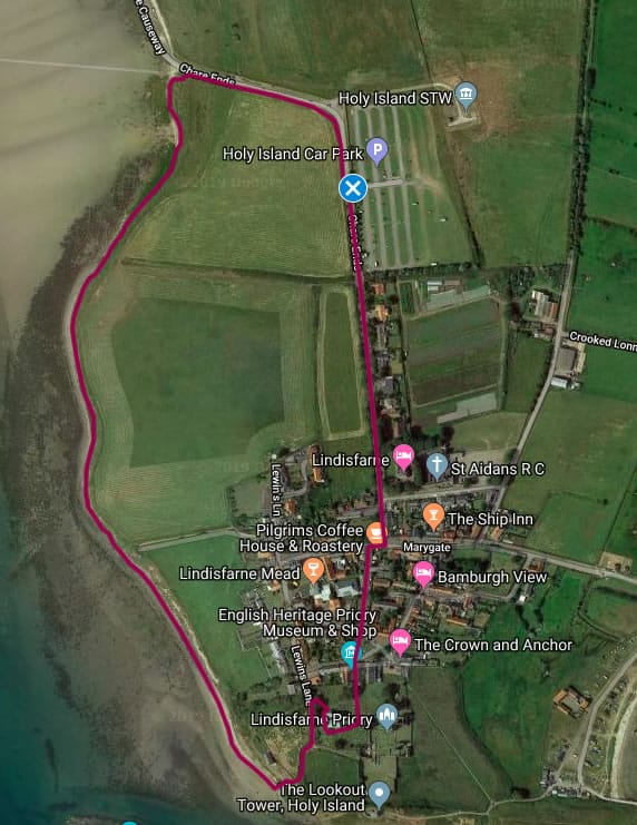
WALK 1: Holy Island upper foreshore walk (circular)

Distance: 1 mile (1.65km)
Time: Approx 25 – 30 minutes
Level: Easy (some walking at height)
Start and end point: Chare Ends Visitors car park, Holy Island.
Points to note: Seal-spotting in summer. Quiet route away from daytrippers and crowds on the island. Some walking on clifftops.
Summary:
This walk includes the foreshore near the village on the south-east of Holy Island, and faces the mainland. This path is great for views and if the tide is high and you only want a relatively short walk away from the village. This path can be close to the edge of cliffs and should only be attempted if you are sure-footed and with appropriate walking shoes. The path also takes in part of the quieter eastern part of the village.
Walk description:
1. The walk starts from the main visitor car park on Chare Ends. Exit the car park and carefully cross over on to the path on the other side of the road, turning right as if you are walking away from the village.
2. In a few minutes, you will come to the shoreline, where the Pilgrim’s Way meets the island (you will see poles leading off in a line towards the horizon). There is a bench on a small rise to your left, if you want to stop and enjoy the views across the sands to the mainland.
3. From the bench, turn left and follow the faint path along the fenceline behind the bench. Enjoy the views to your right across to the mainland, and there may be sheep in the fields to your left.
4. The path will undulate in height, sometimes close to the shoreline, sometimes higher up. Watch out for the edge of the cliff. In summer, you may hear or see seals basking on the sandbanks between here and the mainland.
5. After 10 minutes, the path comes to a small clearing and there is a path to your left, between two fields, take this path, which will lead you towards the village, After the school on your left, cross over and turn right on Lewins Lane.
6. Take the next turning on the left, Marygate, past the old post office, and just on your left is the entrance to the Gospel Gardens, a great place to relax when the island is busy.
7. From the Gospel Gardens, cross over to the other side of the road and continue along Marygate, cross the next turning and at the Pilgrim’s Coffee Shop sign, cross the road and follow the pavement to your left around the corner on to Chare Ends.
8. Continue past the Chare Ends Café on your right and cross over the next turning (Green Lane), following Chare Ends for 5 minutes back to the visitor’s car park, where the walk began.
9. Enjoyed this walk? Feel free to tweet us your pictures @Holy_Island_BV
WALK 2: Holy Island foreshore walk, via Lindisfarne Priory (circular)
Distance: 1.5 miles (2.2km)
Time: Approx 35 – 45 minutes
Level: Moderate (rocky in places)
Start and end point: Chare Ends Visitors car park, Holy Island.
Points to note: Seal-spotting in summer. Quiet route away from daytrippers and crowds on the island. Some walking on rocky part of foreshore (only for sure-footed walkers). Can be wet from seawater in places. Options to visit St. Mary’s Church, the Priory, St. Aidan’s Winery and cafés en-route.
Summary:
This walk includes the foreshore near the village on the south-east of Holy Island, and faces the mainland. This path is great for views and should only be walked at low tide and you only want a relatively short walk away from the village. This path can be wet from the seawater and puddles on the foreshore and should only be attempted if you are sure-footed and with appropriate walking shoes. The path also takes in the main route from the Priory towards the village entrance and can be busy on this section.
Walk description:
1. The walk starts from the main visitor car park on Chare Ends.
2. Exit the car park and carefully cross over on to the path on the other side of the road, turning right as if you are walking away from the village. In a few minutes, you will come to the shoreline, where the Pilgrim’s Way meets the island (you will see poles leading off in a line towards the horizon).
3. There is a bench on a small rise to your left, if you want to stop and enjoy the views across the sands to the mainland. From the bench, turn left and follow the faint path along the foreshore downhill from the bench. You’ll now be walking along the sand and rocks adjacent to the sea. Enjoy the views to your right across to the mainland. In summer, you may hear or see seals basking on the sandbanks between here and the mainland.
4. After 5 – 10 minutes, you will see small cliffs to your left and the foreshore becomes more and more rocky. Weave a path between the rocks, continuing in the same direction.
5. On your left after a few minutes, you may see a rope lying next to the cliff-face. This allows access to a path heading into the east of the village and can provide an escape route if the tide comes in and is especially high. This should only be attempted by those who are physically fit enough to do so.
6. Continue to weave your way through the rocks in the distance you should see a small building on the beach, as well as St. Cuthbert’s Island to the right. Keep going, this last section is increasingly rocky and shouldn’t be attempted at high tide.
7. Eventually, you will reach a sandy beach. The building you saw is the Old Lifeboat Station museum, which has a permanent exhibition about the coastguard and lifeboatmen and villagers of Holy Island.
8. Continue along the beach and follow the path, to the left, that is heading away from the beach, as it veers left and continue uphill, heading towards the church.
9. When you reach a gate on your right into a churchyard, go through this gate and follow the path in the churchyard, right, keeping the church on your right hand-side. You will pass the entrance to the church, which is well worth a visit.
10. Continue past the church and the Priory will appear ahead of you (tickets for entry must be purchased from the Priory museum). Continue following the path as it passes the church and carry straight on through the churchyard. To the right you may spot a statue of St. Aidan and views out towards the harbour and the castle.
11. Go through the church gate and just past the Priory museum on your left you will reach the Market Square. Continue straight on along Crossgate Lane, please note there are no pavements here, so watch out for any traffic. In a couple of minutes, on your left you will pass St. Aidan’s Winery (great for free samples of Lindisfarne Mead), The Crossman Hall (where village events take place) and come to a T-junction.
12. Turn right here and at the Pilgrim’s Coffee Shop sign, cross the road and follow the pavement to your left around the corner on to Chare Ends.
13. Continue past the Chare Ends Café on your right and cross over the next turning (Green Lane), following Chare Ends for 5 minutes back to the visitor’s car park, where the walk began.
14. Enjoyed this walk? Feel free to tweet us your pictures @Holy_Island_BV
WALK 3: Holy Island north beaches and castle walk (circular)
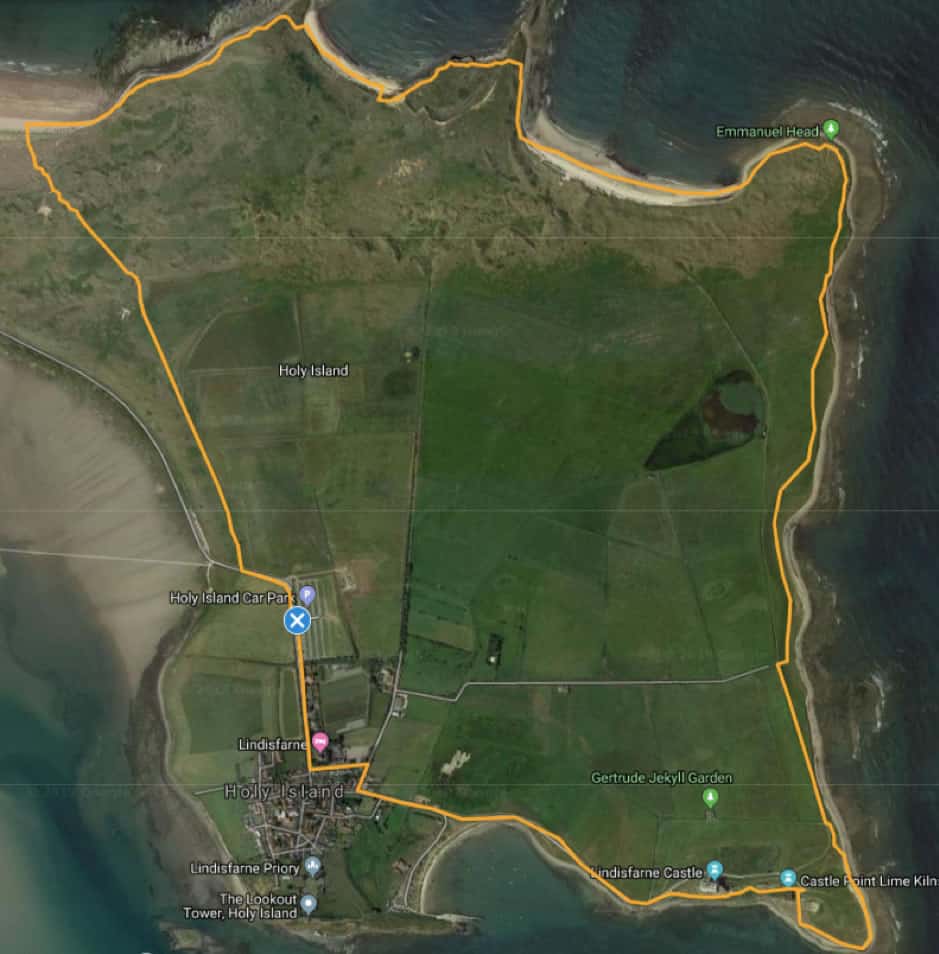
Distance: 5 miles (8.3km)
Time: 2 – 3 hours
Level: Moderate to Hard (steep in places)
Start and end point: Chare Ends Visitors car park, Holy Island.
Points to note: Quiet route away from daytrippers and crowds on the island. Some walking on beaches and through, up to and on to dunes (quite steep in places). Can be wet from seawater in places. Options to visit Castle Point, Lindisfarne Castle, and cafés en-route (in village only). On the dunes, watch out for sand slippage, and your hands when walking through the marram Grass, which is spiky. Also, in summer, watch out for Pirri Pirri Burr, an invasive plant, which has spines that stick to clothing and dogs. Some areas in and around the dunes can be boggy, so suitable walking shoes are recommended.
Summary:
This walk includes the dune system (known as The Links) and three beaches on the northern side of Holy Island, an area generally missed by daytrippers to the island. There are great views out to sea for the majority of this walk, with some steep sections of walking across dunes and on the crest of dunes along the shoreline, and so this walk requires a fairly good level of fitness, surefootedness and good footwear. A great walk for birdwatching and enjoying the coastal scenery. The walk also includes the option to visit Lindisfarne Castle, Castle Point and the castle lime kilns. Towards the end of the walk there are café options in the village.
Walk description:
1. The walk starts from the main visitor car park on Chare Ends.
2. Exit the car park and carefully cross over on to the path on the other side of the road, turning right as if you are walking away from the village. You will come across a warning sign with a tide timetable on your left.
3. Opposite the warning sign and timetable you should see a gate with an information board on the other side of the road. Cross over here carefully as this is the main road in and out of the village on Holy Island.
4. Go through the gate and follow the path as it hugs the fence-line to the right. After 5 minutes or so, the path should enter an open area before the first set of dunes. You may be able to see the foundations of a building built into the dunes ahead and to your left. Keep heading straight on across this open area towards the first set of dunes.
5. Once you are in the dunes, take the left fork and follow the path up and over the dune and into the next open area.
6. Go straight on across this open area between the dunes, passing the ruined building on your right and go straight on through the small gap in the wire fence ahead of you.
7. Continue along this path, over the next two sets of dunes. After this the path will end on a wide beach. This is the north shore and is a typical Northumbrian beach, wide and flat.
8. Turn right on the beach and walk towards the end of the beach, where it starts to get rocky. In the distance you may see numerous birds on the shoreline.
9. At the end of a beach is another wire fence, go over or around the fence and head uphill into the dunes that are ahead of you and are adjacent to the beach, keeping the seashore to your left.
10. Once in the dunes again, keep to the path that follows the crest of the dune, which will undulate and provide beautiful views out to sea. Keep walking past the rocky shore on your left for about 10 -15 minutes, sticking to the path which will head slightly inland and eventually reach an access point to the next beach, Coves Haven, which will be straight ahead of you. The access point can be steep and there is another at the western end of the beach, which is slightly less steep.
11. Walk down to the beach and then along the beach. Coves Haven is a great place to get out of the wind, as it is protected by the dunes from prevailing westerlies. The beach has a set of cliffs and caves at its eastern end, where gulls and other birds nest.
12. Just before the beach ends, look out for a path going back uphill into the dunes, please note this is quite a steep and sandy path, so you will need to persevere to get to back up on to the dune.
13. Once back on the dune, turn left and follow the crest of the dune again until you reach the top of the cliffs you saw from Coves Haven beach. You will get amazing views out to the sea from up here. Be careful of the cliff edge. From here you will see a white pyramid, which is a daymark on Emmanuel Point to stop ships being wrecked on the rocky shore there. Continue along the path, and after 5 minutes you may see an old lime quarry to your right-hand side, as well as Castle Head Rocks to your left. Castle Head Rocks is a headland of flat volcanic rock that can be walked on and – if it is high tide – is a great place to enjoy dramatic waves crashing below. You can scramble around the headland to access Sandham’s bay beach, otherwise retrace your steps back to the path and turn left.
14. Follow the path as it cuts across the headland and as it veers right. You should be able to see Sandhams beach ahead of you, on your left.
15. After a couple of minutes, there should be an access point to the beach on your left. Take this access point and be aware this is quite steep and will bring you out on to the rocks. Beyond the rocks is the sandy part of the beach. Sandham Bay beach is another sheltered beach, that is a great place to get out of the wind and enjoy the lovely views out to sea.
16. Walk along the beach, heading towards the white pyramid that you can see in the distance. At the end of the beach, you should see a path heading up on to the dune on your right. Scramble across the rocks and up the path.
17. Follow this path for a few minutes and you will reach the white pyramid on Emmanuel Point. The pyramid has benches on all sides, so feel free to stop for a rest and enjoy the view out to sea.
18. Follow either of the paths on the other side of the pyramid from which you arrived. Both converge in a few minutes at a junction of paths next to a stone wall.
19. Continue straight on and go through the gap in the fence next to the cliff danger signs.
20. Keep following this path for approximately 20 minutes, heading towards the castle. The path will eventually veer right and inland on an embankment, when the castle is to your right. Before the embankment, turn left off the path on to Castle Point, where you will be on a pebble beach. Immediately in front of you, there should be lots of stone cairns (stones balanced on top of each other). Please don’t add your own. They are a nuisance to the eco-system, and take constant efforts by volunteers to remove them.
21. Follow the pebble beach as it curves around Castle Point for 10 minutes, enjoying the views out to sea and towards the mainland, including Bamburgh Castle and The Farne Islands, in the distance.
22. When you can see the Castle kilns to your right, leave the beach and walk towards the kilns, which are definitely worth exploring. This is where the lime from the quarry on the north of the island was brought for processing.
23. Go around the kilns, keeping them to your left, and climb the steps to the top of the kilns. The castle should be straight ahead of you. Just ahead to the right is Little Beblowe Crag, another hill/vantage point to enjoy views out to sea. This is best accessed from the other side of the hill.
24. Passing Little Beblowe Crag on your right, head uphill towards Lindisfarne Castle. If you want to visit the castle, the ticket office is in front of the castle.
25. Follow the path veering to the left and this will take you past the castle, which will be on your right-hand side. The path will go past the castle and then head downhill. You should be able to see the village ahead, in the distance.
26. After a few minutes, you will come to a set of two kissing gates, both allowing access to the road from the castle to the village, go through either of these.
27. Follow the road for 10-15 minutes, enjoying the views towards the village and in the harbour to your left, until you reach the first turning on the right, which will be in the village.
28. Turn right and follow this road (Sandham Lane) and take the first left onto Green Lane, passing the car park on your right. There are café options here if you need a beverage or a bite to eat.
29. Following the pavement on the right hand side, turn right at the end onto Chare Ends and follow this road for 5 minutes, back to the visitor’s car park where the walk began.
30. Phew: you made it! Enjoyed this walk? When you pass our place (Belvue Guesthouse), feel free to take a smiling selfie next to our sign or our Camino Shell and tweet it at us @Holy_Island_BV
And, if you’re looking to stay on Holy Island when everyone else has to leave (highly recommended!):
Be our guest. We launched our guesthouse in 2019, after we fell in love with Holy Island and escaped from the big smoke. We put a lot of love into a project to renovate Belvue to provide quality accommodation on the Island. Book our luxury accommodation, enthusiastically recommended on Tripadvisor. Details here.