How to walk Saint Cuthbert’s Way
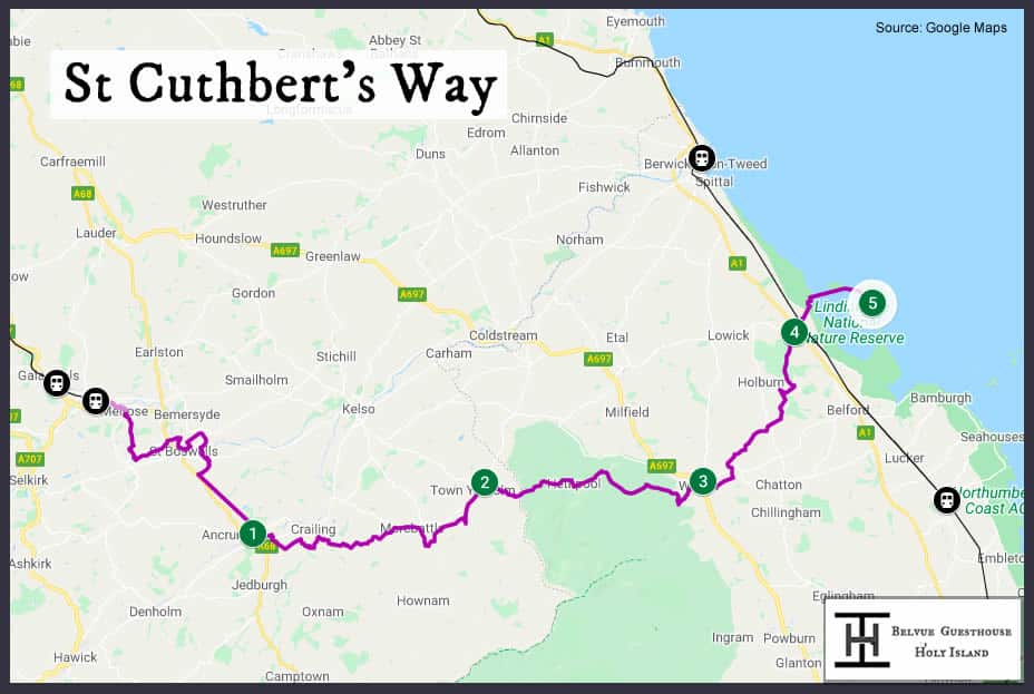
Route overview
This 62-mile (115 kilometres) route follows the ancient pilgrimage route, followed by
St Cuthbert and many other monks between
Melrose Abbey in the Scottish Borders and
the Holy Island of Lindisfarne in north Northumberland. The route crosses the stunning Tweed Valley and Cheviot Hills, before heading across a tidal causeway to the enigmatic Holy Island, via towns and villages, such as St Boswells and Wooler. The route can be walked in either direction, but most pilgrims/walkers walk from Melrose towards Holy Island in 4 – 6 days. We would recommend a 5-day walk, ensuring you read our article about
how to safely cross the causeway to Holy Island.
This short guide provides basic information on each of the 5 recommended daily stages (each between 12 and 16 miles in length) of the walking route from north to south. I’m a long-distance walker myself (with 2.5 Caminos under my belt), so I wrote this guide to help other walkers.
 A more detailed map for this walking route as well as other routes that visit Holy Island can be found on this link.
How to get to the start of the route
The route can be accessed at Tweedbank and Berwick-upon-Tweed (southern end) railway stations, which are a 55 minute and a 45-minute train ride from Edinburgh, respectively. Tweedbank station is the final stop on the Borders Railway branch line from Edinburgh Waverley station, and Berwick-upon-Tweed station is located on the East Coast Main Line, serving destinations between London and Inverness, including Edinburgh and Newcastle. There is a local bus, the #67, that links Melrose to Berwick-upon-Tweed, allowing you to go back to your start point, if you wish.
If like most walkers/pilgrims, you are starting your walk at Melrose.
We would recommend staying in Melrose or Edinburgh (an hour train ride away) before you start walking, allowing you to start your walk towards Harestanes Visitor Centre, the following day. Both Edinburgh and Melrose have numerous cafes and places to eat, as well as pubs and accommodation. If joining St. Cuthbert’s Way from Edinburgh, via Tweedbank station, there is a pathway linking Tweedbank to Melrose, which can be found immediately across the other side of the road from the station entrance. Look out for a blue direction sign to Borders Hospital and Melrose, which will follow the River Tweed for 2 miles and into Melrose, where the Abbey will appear on your left.
Stage 1 – Melrose to Harestanes Visitor Centre (15 miles)
This stage takes you from the start point of Melrose Abbey, through the Eildon Hills and via the pretty villages of Newton St Bothwell’s and St. Boswell’s, the River Tweed and along a Roman road (Dere Street) to the visitor centre at Harestanes. There are accommodation options in Melrose, St Boswells, and beyond Harestanes in the town of Jedburgh (a 4-mile taxi ride from Harestanes), where there are also a number of places to eat. Locations that can be visited en-route are:
- Eildon Hills – distinctive hills overlooking Melrose and surrounding area, with great views out over the Scottish Borders.
- Dryburgh Abbey – a ruined abbey on the northern bank of the Tweed. The burial location for Sir Walter Scott and his family.
- St Boswells – a large village, which is a great stop off for places to eat, and places to stay.
- River Tweed – the path follows the meandering course of this river, and there are many beautiful views across the river to enjoy.
- Peniel Heugh – a local viewpoint with a tall Waterloo monument, which you can climb up, and which provides great views across the Tweed and Teviot valleys.
- Monteviot House and Gardens – beautiful manor house set in 30 acres of land, that includes the beautiful rose and water gardens amongst many.
- Harestanes Visitor Centre – an information centre for visitors to the Scottish Borders, with cafe and information about the local area.
Stage 2 – Harestanes Visitor Centre to Kirk Yetholm (17.5 miles)
From Harestanes Visitor Centre, a slightly longer walk today, crossing lanes and farmland, passing by Cessford Castle through the village of Morebattle – a great place to stop for food and a drink, and then through the west of the Cheviot Hills, arriving at twin villages of Town Yetholm and Kirk Yetholm, both of which have pubs and accommodation. Locations that can be visited en-route are:
- Cessford Castle – a ruined castle, which used to be home to a notorious reiver family, the Kerrs.
- Morebattle – a cute village with a village shop and pub, a great place to stop for food. There is also accommodation here.
- Wideopen Hill – the highest and approximate halfway point on St. Cuthbert’s Way, with great views across the surrounding countryside and Cheviot hills.
- Town Yetholm – another stopping point, with a shop and pub, also accommodation.
- Kirk Yetholm – the end of this stage and also the Pennine Way, so there are accommodation options, a pub and a shop.
Stage 3 – Kirk Yetholm to Wooler (15 miles)
This stage traverses The Cheviots, a set of hills/mountains, into England and Northumberland, before ending at the market town of Wooler, which has all amenities, needed. There are no facilities between Kirk Yetholm and Wooler, except for a bed and breakfast in Hethpool, almost halfway along the route. So, please plan, accordingly. Locations that can be visited en-route are:
- The Cheviot Hills – stunning hills with moorland, which provide the backdrop to today’s walk. The hills are criss-crossed by streams, and also with small waterfalls close to the route
- Yeavering Bell – an iron-age fort located on a hilltop just off the walkway. The fort was a tribal centre for the Votadini, a local Celtic tribe who used to rule the local area.
- Wooler – a pretty town, with all amenities, including pubs, cafes, restaurants, some independent shops and a small supermarket
Stage 4 – Wooler to Fenwick (12 miles)
This stage crosses the north Northumberland countryside heading towards Holy Island. From Wooler, the route crosses farmland and woods, before passing St. Cuthbert’s Cave and then onward to the small village of Fenwick, where there is some accommodation. There are no services en-route beyond Wooler. Pubs can be found a few miles away at Lowick and on the A1 at West Mains (where there is also accommodation, if required). Locations that can be visited en-route are:
- St Cuthbert’s Cave – an alleged stopping point for the monks who were moving St. Cuthbert’s body from The Holy island of Lindisfarne to Durham, where he is now buried. Worth a visit.
- Kyloe Hills – a set of hills providing panoramic views across to Holy Island and north Northumberland Coast, close to the end of this stage
- Fenwick – the final stop on this stage, with bed and breakfast accommodation
It is possible to cover the final stage (Stage 5) on the same day, depending if you would arrive at the causeway to Holy Island at low tide. This would also add a further 6 miles to the walk, but this means that you would arrive at the village on Holy Island, which has more amenities than Fenwick. If you realise that you cannot cross, but want to get closer, there are accommodation options at West Mains, the turnoff to Holy Island off the A1, where there is a pub/hotel and a hostel. Please read Stage 5 for further information on this stage of the route.
Stage 5 – Fenwick to Holy Island (6 miles)
The final stage runs through farmland, then across the causeway to Holy Island, the final destination for this pilgrimage/walk. You can either follow the causeway road, which is tarmacked but shared with car traffic (there is no pavement) and can be crossed at low tide, or if the tide is receding you can follow the Pilgrim’s Path across the sands to Holy Island. Make sure you
read our instructions about how to cross the causeway safely. If not, accommodation can be found at West Mains (10 miles), a 1 mile detour each way from this route, where the approach road to Holy Island meets the A1 main road. If you are unable to cross the Lindisfarne Causeway, toilets can be found at the petrol station at West Mains on the A1. Locations that can be visited en-route are:
- Beal – a small hamlet on the road to Holy Island, where there is a café and bar, where you can stop for a rest and some food. There is accommodation a mile from here, back at the A1, if required and the tide is blocking the road to Hoy Island.
- Lindisfarne Causeway – the beautiful access to Holy Island, shared with car traffic.
- Pilgrim’s Way – a pedestrian-only path across the sands to Holy Island. This should only be crossed on a waning tide.
This final stage ends at Holy Island – a beautiful tidal island with a strong religious history and amazing wildlife and landscape.
The village on Holy Island has amenities, including cafes, museums, a castle, tourist shops, pubs and accommodation for visitors, which should be booked in advance.
Instructions on how to follow this stage can be found
here.
Staying the night on Holy Island?
Come stay with us, of course. We loved Holy Island so much, we moved here in 2017 and opened a guesthouse with three comfortable rooms.
Details of our rooms can be found here.
Looking for more information about Saint Cuthbert’s Way?
Visit the
St Cuthbert’s Way website and click on the relevant stage.
Other Long Distance walks to Holy Island
See our
write-ups of other pilgrimages/long-distance routes to Holy Island.